The maps below are for informational purposes only. Maps include:
- Construction Activities MapPDF • 207 KB
- Dam Site Area
Site Preparation North BankPDF • 7.7 MB
Site Preparation South BankPDF • 8.9 MB
- Roads and Highways
240, 269 and Old Fort RoadsPDF • 7.7 MB
271 RoadPDF • 3.9 MB
The proposed Site C project is located in northeast British Columbia, seven kilometres southwest of Fort St. John. The coordinates are: 56N, 12', 4.59" Latitude, 120W, 54', 21.76" Longitude.
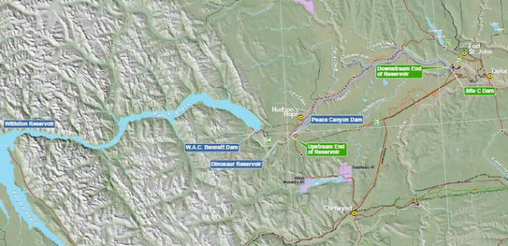
This map shows the Site C Clean Energy Project within the Peace Region.
These maps show preliminary impact lines, Highway 29 realignments and the agriculture assessment around the Site C reservoir.
- Map 1 of 26 – Kilometre 21 – 27 Peace Canyon Dam PDF • 6.1 MB
- Map 2 of 26 – Kilometre 26 – 32 Hudson's Hope PDF • 5.6 MB
- Map 3 of 26 – Kilometre 32 – 37 Lynx Creek PDF • 5.9 MB
- Map 4 of 26 – Kilometre 37 – 45 Lynx Creek to Farrell Creek PDF • 5.8 MB
- Map 5 of 26 – Kilometre 43 – 51 Farrell Creek PDF • 5.6 MB
- Map 6 of 26 – Kilometre 49 – 56 Farrell Creek East PDF • 6.1 MB
- Map 7 of 26 – Kilometre 54 – 62 Farrell Creek to Halfway River PDF • 6.0 MB
- Map 8 of 26 – Kilometre 59 – 67 Attachie Slide PDF • 6.0 MB
- Map 9 of 26 – Halfway River PDF • 5.5 MB
- Map 10 of 26 – Kilometre 67 – 72 Halfway River/Attachie Lookout PDF • 5.4 MB
- Map 11 of 26 – Kilometre 72 – 81 Watson Hill/Watson Slough PDF • 5.4 MB
- Map 12 of 26 – Cache Creek/Red Creek PDF • 5.2 MB
- Map 13 of 26 – Cache Creek Slide PDF • 5.6 MB
- Map 14 of 26 – Kilometre 87 – 96 Wilder Creek PDF • 5.7 MB
- Map 15 of 26 – Kilometre 95 – 104 Tea Creek PDF • 5.4 MB
- Map 16 of 26 – Kilometre 102 – 106 Site C Dam Location PDF • 5.7 MB
- Map 17 of 26 – Moberly River PDF • 5.6 MB
- Map 18 of 26 – Kilometre 107 – 115 PDF • 4.7 MB
- Map 19 of 26 – Kilometre 111 – 119 PDF • 4.6 MB
- Map 20 of 26 – Kilometre 117 – 123 PDF • 4.7 MB
- Map 21 of 26 – Kilometre 123 – 131 PDF • 4.6 MB
- Map 22 of 26 – Kilometre 130 – 139 PDF • 4.2 MB
- Map 23 of 26 – Kilometre 139 – 146 PDF • 4.4 MB
- Map 24 of 26 – Kilometre 147 – 154 PDF • 4.3 MB
- Map 25 of 26 – Kilometre 154 – 162 PDF • 4.3 MB
- Map 26 of 26 – Kilometre 162 – 168 PDF • 4.6 MB